Three sets of twins – two of them unusual tourist delights – await the intrepid traveler who explores the area around the industrial cities of Gómez Palacio and Torreón in northern Mexico.
The first, and most obvious, pair of twins is the two cities themselves, which lie either side of the River Nazas. Gómez Palacio is in the state of Durango, Torreón in Coahuila, the river forming the boundary between the two. Road signs are confusing, to say the least, and most motorists spend longer than they had originally intended reaching their hotel. Torreón has more hotels than Gómez Palacio with several good downtown choices, including the Rio Nazas hotel, with its subterranean parking, catering to tourist and business traffic.
Downtown Torreón is lively and noisy despite its wide avenues. Hawkers vie for your attention, birds perched in the tall trees of the plaza chatter through the evening and formally-attired local dignitaries stroll side-by-side discussing their latest business and social transactions. Though Torreón is primarily a business and commercial center, it does house several tourist attractions, more than can be said for its poorer, across-the-river neighbor Gómez Palacio. Torreón has a splendid city park, with a new Regional Archaeological Museum (Museo Regional de la Laguna), several other museums and a country club with golf course.
BRIDGE IN THE MIST AND MEXICO’S GEMSTONE CAPITAL
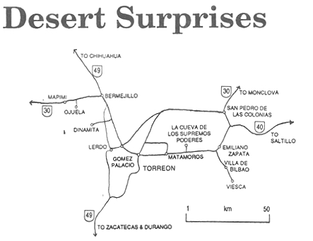
North-west of Gómez Palacio, past the turning to the inappropriately quiet town of Dinamita (Dynamite), lies the second set of twins: Mapimí and Ojuela. To reach them from Gomez Palacio or Torreón, first take federal highway 49 northwards (follow signs for Chihuahua and stay on the free, non-toll road) as far as Bermejillo, a decaying one street town with two small motels, several rock shops and a railway station. From Bermejillo, take highway 30 (signed La Zarca) to the west. Fifteen minutes along here, a signpost indicates that “Puente de Ojuelas” is somewhere off to your left.
This is decision-time! If unsure of your vehicle’s (or driver’s) capabilities, then hire a local truck for the next stage. However, if you are driving a vehicle with high clearance and adequate power, then simply pay your toll (about 50 cents US) and bump your way seven kilometers across the desert on a gravel road to the base of the hills, taking the well-worn left fork part way there. Ahead of you, a steep cement and rock road leading up the hillside will confirm that you are in the right place! This one car wide road, with blind bends, should be navigated with great caution and probably not attempted in wet weather (a rare event in these parts). At the end of the road several surprises await you!
A ghostly air pervades the hillside, especially if mist hangs on the slopes. Ruined stone houses tell of former wealth. You are naturally drawn towards a stupendous view across a deep canyon and towards a mysteriously restored bridge.
Ore was first discovered here in 1598. By 1777, seven ” haciendas de beneficio” (enrichment plants) served thirteen different mines. In 1848, the Spanish mine owners gave up their struggle to make the mines pay and a Mexican company took over. In 1892 they decided to attack the hillside opposite Ojuela. To shortcut the approach, an engineer, Santiago Minguin, spanned the gorge with a 315-metre-long suspension bridge, said by some to be the third longest in Latin America. The mine’s production peaked just after the Mexican Revolution. Between 1922 and 1925, 687 kilograms of gold and 99,820 kilos of silver were extracted, alongside more than 51 million kilos of lead and a million kilos of copper. At that time, some 3,000 miners celebrated every evening in the bars of Ojuela, now completely abandoned to the elements.
The bridge, restored for its centenary, is a worthy contribution to future tourism in Durango state. One and a half metres wide, it sways and bounces in the breeze, probably scaring mums and dads into silent concentration faster than their excited children! But the local miners and their mineral-laden donkeys rattle across the planks as if it were a highway. Once across the bridge, old timers will take you on a one kilometer walk along mine galleries (unlit except for hand-held miners’ lamps) which completely traverse the mountain to emerge into daylight on the far side.
A local guide may offer to drive you in his truck to see some “nearby” caves. This will turn out to be a 5-hour round trip, not exactly a short expedition, merely confirming that all distances in this huge swathe of desert are relative!
Back on the highway and anxious for refreshments? Continue west for a few kilometers and enter the small and historic town of Mapimí. The Tepehuan Indians called this place “the rock on the hill” and repeatedly thwarted the attempts of Jesuit missionaries to found a town here. ** See Map Below) The gold-thirsty Jesuits won in the end; rumour has it that gold was even found under the streets.

Even if the town once had too many children, it doesn’t now, apparently. Visitors entering the town are greeted by a sign proclaiming that ” Aquí no sobran niños” (Here children are not in oversupply). Below, in much larger letters, is “¡ Maneja con cuidado!” (Drive Carefully!).
A two room museum half a block off the plaza, on the same side as the eighteenth century church, has mementos and photos from the old days when this was a prosperous mining town, and a gem shop (agates, selenite crystals and calcite) for the geologist in the family. One handbook to gem collecting in Mexico describes Mapimí as the “mineral collector’s capital of Mexico”.
According to the museum’s display, we owe the preservation of the suspension bridge at Ojuela to a Señor Carlos González who, when ordered by executives of his mining company to take 50 men and obliterate the town of Ojuelas, prevaricated sufficiently for a “rescue” campaign to save the bridge. A Mexican’s ” mañana-syndrome” won one for the nation! Other prominent mines in this region, all served by Mapimí, were San Vicente, Socavón, Sta. Rita, Sta. María, El Carmen, La Soledad, and the presumably traitorous Judas.
Like seemingly every town in this region of Mexico, Mapimí boasts that both Miguel Hidalgo, the Father of Mexican Independence, and Benito Juárez, the President of Indian blood, passed by in the nineteenth century. Juárez even stayed overnight.
A DATE IN THE DUNES
Our third set of desert twins is totally different. East of Torreón, towards Parras and Saltillo (turn right at Emiliano Zapata), are the small settlements of Villa de Bilbao and Viesca. Both Hidalgo (then a prisoner) and Juárez also visited both places, staying overnight in the latter-named.
In Viesca, in 1864, Juárez, a guest in General Jesús González Herrera’s home at number 19, Hidalgo street, was introduced to the patriotic Mexicans who would soon become the official guardians of the federal archives which Juárez was carrying with him. The archives were hidden for several years in a cave, then known as La Cueva del Tabaco (Tobacco Cave), but now renamed La Cueva de los Supremos Poderes (The Cave of the Supreme Powers), before being restored to the nation in 1867 after the French left and Maximilian was executed. The cave is about 12 kilometers east of Matamoros. While there is little to see there today, this important event in national history is one rightfully remembered by all Mexicans and the entrance to the cave is via an impressive, modern, stone stairway.
Villa de Bilbao is the nearest village to the twin attractions of cheap dates (the kind that grow on palm trees) and an amazing landscape of easily accessible desert sand dunes, Las Dunas de Bilbao, only a nine-iron sandtrap shot from the highway. The dunes have provided the backdrop or set for numerous movies. It’s fun to explore the dunes which are surprisingly free of signs of human activity (even garbage is rare to find here) and don’t pass up the opportunity to slide down them, just for fun. The dunes are not completely devoid of vegetation, but don’t expect to find very much shade.
Several homes in Bilbao sell boxes of dates – at prices which are extremely reasonable, even if the weights marked on the packages are somewhat suspect. A dirt road from Bilbao leads to the ruined ex-hacienda of Venustiano Carranza, about 12 kilometers away.
SHOULD THE SOUTHERN TEPEHUAN INDIANS WEAR CLOTHES, AND IF SO WHAT STYLE?
According to Chloë Sayer in Costumes of Mexico , “Spanish priests were equally shocked by Indian nudity. A report for 1645 by Andrés Pérez de Ribas described the efforts of priests to obtain clothing for the nude Tepehuan of northern Mexico…” Centuries later, the Spanish had successfully persuaded most of the Indians to abandon traditional dress (men wore loin cloths only) in favour of “Mexican” attire. But then the pendulum swung in the opposite direction, back towards traditional attire. Among several “new apparitions” described by John Bierhorst in The Mythology of Mexico and Central America is the story of The Virgin of Cerro Amarillo. In 1956, a young southern Tepehuan woman saw the Virgin of Guadalupe, who spoke to her, requesting that a chapel be constructed and that the people stop wearing Mexican clothes.


