Did You Know…?
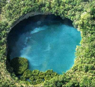
As vertical shafts go, this is a seriously deep one! Long considered to be “bottomless” since no-one had ever managed to find the floor, we now know it is precisely 335 meters (1099 feet) deep, making it the deepest water-filled sinkhole anywhere on the planet.
The El Zacatón sinkhole is on El Rancho Azufrosa, near the town of Aldama in Tamaulipas in northeast Mexico. The sinkhole or cenote is one of several located in the same area, though recent studies have failed to demonstrate any obvious underground connections between them. The term cenote is a Spanish rendering of the Mayan word d’zonot, “a hole in the ground”. The El Zacatón pit, which is about 110 meters (360 feet) across and roughly circular, contains a deep lake. The water is warm (averaging about 30o C), highly mineralized and has a sulphurous odor. The name El Zacatón comes from the floating islands of grass (zacate) which blow across this lake from one side to the other with the wind.

The pit’s depth has attracted serious divers for many years. In 1993, it was the site for Dr. Ann Kristovich’s dive to a new women’s world record depth of 169 meters (554 feet). The following year, two American explorers attempted to dive to the bottom of the sinkhole. Jim Bowden successfully reached a men’s world record depth of 282 meters (925 feet) but still did not touch the bottom. Tragically, his diving partner Sheck Exley died during the attempt.
The mystery of the sinkhole’s depth was finally solved in 2007 in a multi-million dollar exploration, mainly funded by NASA. NASA‘s Deep Phreatic Thermal Explorer (DEPTHX) project is developing a robot that can explore ice-covered Europa, Jupiter’s smallest moon. Partners on the DEPTHX project include Carnegie Mellon University, Southwest Research Institute, Colorado School of Mines, The University of Arizona, and the University of Texas at Austin’s Jackson School of Geosciences. In the words of a NASA press release, The Deep Phreatic Thermal Explorer (DEPTHX) is a 3,300-pound, computerized, underwater vehicle that makes its own decisions. With more than 100 sensors, 36 onboard computers, and 16 thrusters and actuators, it decides where to swim, which samples to collect and how to get home.
Exploring El Zacatón pit was considered to be an ideal preliminary test of the DEPTHX autonomous robot, which is about the size of a go-kart. The robotic vehicle successfully generated a highly detailed sonar map of the sinkhole, and obtained samples of water and biotic material from the walls, discovering several new phyla of bacteria in the process. Its next challenge is to explore beneath the ice of West Lake Bonney in Antarctica.
At El Zacatón, the sonar study showed that the sinkhole has a total depth of 335 meters: the lake is 319 meters deep at its deepest point, and its surface is 16 meters below the height of the sinkhole’s rim.
How did such a large sinkhole form?
Most major sinkholes form as a result of the collapse of the ceilings of underground cavities which have been formed by the gradual dissolution of limestone due to percolating acidic rainwater. However, according to Marcus Gary, of the Jackson School of Geosciences at the University of Texas at Austin, who has studied this area since the 1990s, the Zacatón pit is not a conventional sinkhole. He believes that this pit began to form in the Pleistocene period as a result of underground volcanic activity. Volcanism increased the acidity of water deep underground which then gradually ate away at the surrounding limestone in a process known as “hypogenic karstification”. As the underground caverns grew larger, the overlying rock would periodically collapse into them, eventually leaving giant pits extending to the surface above.
Equally interestingly, some of the sinkholes appear to be closing over. All the major sinkholes in Tamaulipas contain lakes and in several cases, they appear to be crusting over with travertine, a form of calcium carbonate which, in the right conditions, can be precipitated out of calcium bicarbonate-rich water. According to Marc Airhart, another researcher at the Jackson School of Geosciences, the process is probably an excruciatingly slow one, but at least one sinkhole (Poza Seca) has closed up entirely, sealing off an underwater lake. This travertine skin may also explain why El Zacatón has floating islands. It seems likely that pioneer species may have colonized small rafts of travertine, beginning the series of ecological processes that resulted in the grassy islands that can be seen there today.
Sources / Further reading:

