Interactive Map of Chihuahua

Interactive Map of Chihuahua

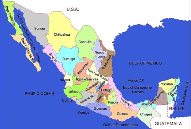
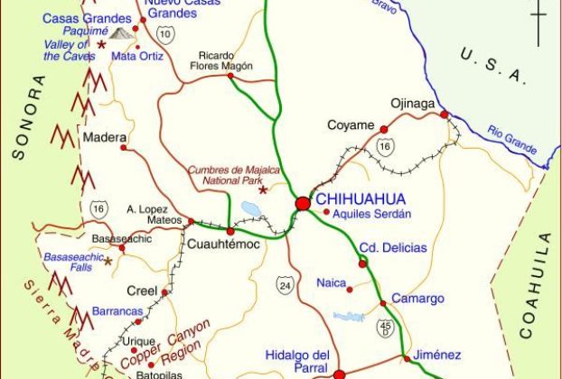
Interactive Map of Chihuahua The map shows the state of Chihuahua in northern Mexico. The state capital is the city of Chihuahua (2020 population: 1,050,000). Chihuahua is the largest state in Mexico in area: 247,087 square kilometers  (95,401 square miles). The state’s population is about 3,700,000. Ciudad Juárez is the state’s largest city and Mexico’s […]

Continue Reading
Interactive Map of Yucatan, Mexico

Interactive Map of Yucatan State, Mexico

Interactive Map of Yucatán, Mexico The state of Yucatán is part of the Yucatán Peninsula region, along with Campeche and Quintana Roo. This region is the ancestral home of the Maya. Yucatán state has an area of 39,612 square kilometers and a population of 1,945,840 (2010 estimate). The state’s capital city  is Mérida, the “white […]

Continue Reading
Interactive map of Pacific Coast beaches: Jalisco, Nayarit, Colima, Michoacán, Mexico

Interactive map of Pacific Coast beaches: Jalisco, Nayarit, Colima, Michoacán, Mexico

Interactive map of Pacific Coast beaches in the states of Jalisco, Nayarit, Colima and Michoacán, Mexico The interactive map shows the coasts of the states of Nayarit, Jalisco, Colima and Michoacán. These states all have some great beaches, and tourism is an important activity in many of the towns shown on the map. Some of […]

Continue Reading
Basic Map of Lake Chapala

Link to clickable interactive map of Lake Chapala

Click on map for interactive PDF map of Lake Chapala: Chapala, Ajijic, Jocotepec, San Juan Cosala, San Antonio Tlayacapan and other villages. Click on map for interactive PDF map of Lake Chapala: Chapala, Ajijic, Jocotepec, San Juan Cosala, San Antonio Tlayacapan and other villages. Published March 1, 2009. © 2009. Cartography by Tony Burton.

Continue Reading